

Download The Climate Impact Company Tropical Report
Pictured: Satellite view of the busy tropical North Atlantic.
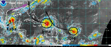
Discussion: Category 5 Major Hurricane Irma is located 110 miles north of Punta Cana, DR moving WNW at 18 mph with max wind near 180 mph and pressure 921 MB. Irma is riding the southwest periphery of the Bermuda High. A strong upper trough moves into the East-Central U.S. the next couple days and erodes the western extension of the Bermuda High allowing Irma to turn northwest and north the second half of the upcoming weekend. NOAA/NHC indicates Irma is a category 4 hurricane striking Miami late Sunday morning then move offshore the middle East Coast of Florida early Monday and making a second landfall near Savannah, GA late Monday evening also as a major hurricane. Tropical cyclone models are slightly east missing Miami with landfall on the South Carolina coast. The right turn by Irma will determine the severity of weather for Florida and the Southeast U.S.
Hurricane Jose is moving west-northwest at 18 mph into the central tropical North Atlantic becoming a major hurricane within 24 hours. Jose travels west-northwest as a major hurricane very close to the islands struck by Irma the past couple days. Upper shear weakens Jose in 5-6 days well north of the Dominican Republic. The day 6-10 forecast for Jose indicates an eastward turn and either accelerating northeastward or possibly looping back to the west and toward Florida (ECM model solution).
Katia is stationary in the southwest Gulf of Mexico and forecast to eventually turn southwestward and strike Mexico in the western Bay of Campeche as a hurricane this weekend.


