

Download The Climate Impact Company Major Hurricane Irma Report
Irma is just north of the north-central Cuba coast yet amazingly maintains strong category 4 intensity ignoring the interaction with the mountainous terrain of Cuba. The NOAA/NHC 5-day forecast is ever-so-slightly further west than late yesterday turning Irma northwestward tomorrow morning as Irma rides the southwest side of an east-shifting and weaker Bermuda High then north-northwest feeling shear in the higher levels of the atmosphere. The NOAA/NHC forecast track takes Irma inland in southwest Florida near or just south of Fort Myers. Climate Impact Co. is using the ECMWF model for landfall which is a little farther north between Sarasota and Port Charlotte.
The storm surge forecast models indicate >9 feet in the Cape Coral. Bonita Springs, Naples, Marco Island and Everglade City areas. The ECMWF model indicates this storm surge potential could be slightly further north into Port Charlotte.
The 5-day forecast indicates Irma moves north over the Tampa area late Sunday night and weakens to a tropical storm in south-southwest Georgia later Monday. Irma turns into the Tennessee Valley and weakens to a depression Tuesday night.
Forecast models are in general agreement with the NOAA/NHC track including the ECMWF model. The trend has been slightly further west and we’re still awaiting the all-important northwest to north turn of Irma. If Irma stays slightly offshore then all of the west coast of the Florida Peninsula would experience major hurricane conditions.

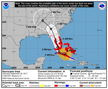
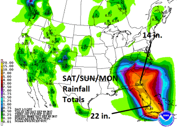
Pictured: Recent satellite view of Major Hurricane Irma (left), NOAA/NHC 5-day forecast track (center) and NOAA/WPC 72-hour rainfall forecast (right).


