


Pictured: October 2017 temperature anomalies and percent of normal rainfall across Australia.
Another exceptionally warm month across Australia with temperature anomalies between 1C and 3C above normal across about 80% of the continent. Rainfall was heavy in Western Australia, Queensland and east-central Australia. The strongest Madden Julian oscillation episode since 2015 forced the excessive rain and contributed to the anomalous warmth. La Nina is developing and weak positive Indian Ocean Dipole was present.


Pictured: The Climate Impact Company week 2 ahead temperature and precipitation anomaly forecast for Australia.
High pressure is dominant east of Australia across warm SSTA. A warm wind flow around the subtropical high pressure center keeps most of Australia somewhat warmer than normal during the period. Influence of the wet phase of the Madden Julian oscillation brings a steady fetch of showers and thunderstorms to wet-central to southern Australia during the period.


Pictured: The Climate Impact Company week 3 ahead temperature and precipitation anomaly forecast for Australia.
MJO shifts to the East Pacific/Atlantic (phase_8) which supports a hot and dry spell for Australia.
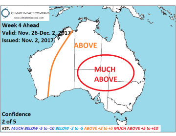

Pictured: The Climate Impact Company week 4 ahead temperature and precipitation anomaly forecast for Australia.
Wet influence of the MJO is back in the West while the East is hot/dry.


