

 South American Forecast Improves: There are limited changes to the overall pattern through the next two weeks, but the extended forecast has trended a bit drier in S Brazil, Paraguay and Argentina – which is needed. The GFS’s week 1 (top) and week 2 (bottom) is favorable should the extended forecast verify, growing conditions will be near ideal.
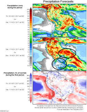
Heavy precip will be spread across a vast majority of South America into early next week. This is good for Central Brazil but unwanted elsewhere. Beginning next Wed/Thurs South America’s jets stream shifts farther south, allowing rainfall to be limited to tropical events in Central and Northern Brazil, where cumulative rainfall is still well behind average. Normal temps and a lack of soaking rain will allow planting to accelerate in Argentina & Paraguay. No excessive heat is indicated in any region into mid November.
 US Forecast Again Unchanged; Wet Pattern Continues in East: A steady flow of lite rain will sustain a sluggish pace of harvest across the Northern and Eastern Midwest over the next 10 days. Corn harvest through last Sunday in the E Midwest is below, and ARC doubts much progress has been made there since. On a weighted average, harvest progress as of week 43 is 47% complete in the states listed below, vs. 63% a year ago.
A swirling low pressure Trough aloft Canada will continue to feed moisture into the Eastern US into mid-November. A rather weekend lies ahead, with NOAA’s QPF indicated cumulative rainfall of .50-3.00” across the E Midwest, favoring IN, MI & OH. Yet more rain across east of the MS River Nov 12-15, and climate guidance maintains above normal precip there in the second half of the month. A warmer Central US temp profile lies ahead, but highs in the 50s & 60s will keep evaporation slowed.
A much more favorable outlook is offered to the Western Ag Belt, where highs will reach into the 60s and where little/no precip is forecast through Nov 17th.


