


Pictured: Current snow cover and the ECM ENS 15-day snowfall forecast.
Currently, snow cover across North America has nearly covered Canada and advanced into the Northwest and North-Central U.S. ahead of climatology. The 15-day snowfall forecast issued by the European ensemble identifies piling snows over Ontario, Quebec to the northern Great Lakes region and into New England. Heavy snows also accumulate over west/southwest Canada and into the Northwest U.S. There is a noticeable lack of snow into the northwest Great Plains. The increasing snow cover will bias the Canadian climate colder than normal and increase the risk of cold weather into the U.S. across and nearby snow covered areas in November.
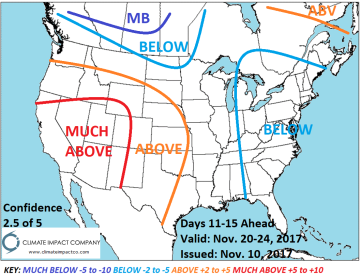
Interestingly, the prevailing climate pattern is warmer than normal but the influence of increasing snow cover on U.S. climate is to keep most of the warmth south of snow cover in the Central and West U.S. Forecasts indicate an emerging blocking pattern as Thanksgiving Week arrives. Models are uncertain regarding intensity of the blocking pattern which is represented by negative phase of the arctic oscillation. If the -AO is intense the risk of cold air generating climate and major storms increases in the East. The Great Plains are largely on the dry side of this potential stormy and colder pattern in the extended-range.


Pictured: The Climate Impact Company medium and extended-range temperature anomaly forecasts.


