

La Nina is here and official onset announced by NOAA is likely in December. However, if you’re applying past La Nina episodes to make an assessment of what winter 2017-18 will bring I would advise caution. As with many ENSO regimes nowadays there are other aspects of the global SSTA pattern(s) interrupting standard ENSO climatology which were fairly reliable in years past.

Fig. 1: In the good old days this what La Nina looked like across the Pacific Basin. Note the cool inflow in both hemispheres into the equatorial region creating a horseshoe effect.
So let’s take a look at the last full throttle La Nina at this time of the year. In October 2010 La Nina arrived enhanced by cool inflow from the subtropics in both hemispheres driven by the California and Humboldt currents (Fig. 1). Produced was the classic cold SSTA horseshoe pattern in each hemisphere as cool SSTA arced from the polar region to the west cost of the Americas and westward into the Pacific tropics. This SSTA pattern drove La Nina climate as we understand it to be throughout modern history.
Now take a look at the current eastern Pacific SSTA pattern which identifies developing La Nina BUT a large area of very warm surface water north of the cool La Nina waters (Fig. 2). The change in cool pattern near the equator to super warmth southwest of Baja California has never occurred before. It’s somewhat of a miracle that there’s enough energy in the atmosphere to drive trade winds to up-well cool subsurface water given the nearby warm SSTA. True to form of the past 4-5 years the North Atlantic chimes in with a record warm surface for mid-to-late autumn (Fig. 3).
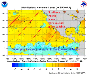

Fig. 2-3: La Nina 2017 is developing with an unusual warm scenario to the north across the southeast North Pacific (left). The warmest North Atlantic surface on record for mid-to-late autumn is present (right).
Normally, La Nina winter drives a wet/cool pattern across the western U.S. (caused by the cooler Pacific) while east of the Divide and especially across the South and East temperatures are warm. But this altered La Nina is likely to change the La Nina climatology. What we’re seeing is a persistent ridge along and of the U.S. East Coast and a large ridge pattern over the Southwest U.S. leaving the door open for a polar vortex to sit in-between and sometimes push cold and snow southward into the East-Central U.S. (Fig. 4).

Fig. 4: The 30-day upper air pattern may be a precursor for winter ahead. Warm SSTA in the southeast Pacific drive a Southwest U.S. ridge and warm North Atlantic SSTA drive an upper ridge over the Northwest U.S. and eastward. In-between is SUSCEPTIBILITY to cold and snow driven south by the polar vortex.
Summary: Normally, La Nina drives a dry/warm ridge across the Southeast U.S. during winter time while the Northwest is wet and cool. That pattern is likely altered this winter while La Nina matures. The adjusted pattern is more likely to feature a warm upper ridge over the Southwest U.S. Meanwhile the warm North Atlantic promotes a western North Atlantic basin upper ridge. In-between the two ridge features the Canadian polar vortex churns cold air that can occasionally surge toward the Southeast U.S. moderating shifting into the East.


