

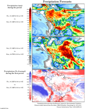
 Moisture to Returns to Brazil in 9 Days; Argentina Much Too Dry: The major forecasting models are in agreement that normal rainfall returns to Central & Northern Brazil beginning late next week, but they also agree that warmth and dryness will persist in Argentina into late January. At left is the GFS’s week 1 (top) and week 2 precip forecast. Argentina’s crop belt is highlighted. Note, that a vast majority of Argentina’s corn crop is currently silking.
A high pressure Ridge is anchored aloft in Central Brazil will begin to lose amplitude early next week and fade away by early next week. A normal flow of moisture resumes in all but NE Brazil thereafter into late month.
However, the South American jet stream’s position will not be positioned favorably for Argentina, and only the far north of the country (which accounts for 10% of corn production) will see meaningful rainfall over the next two weeks.
High temps in Argentina will continue in the low 90s, thus triggering yet more declines in soil moisture.
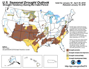 US Pattern Unchanged; Early Feb Trending Drier: The US upper air flow may allow some moisture into the far eastern sections of OK & KS, but otherwise complete dryness will continue across the Plains. The CFS model’s outlook for the first week of February hints at ongoing dryness, and so a pattern shift in the medium term is unlikely. NOAA’s latest drought outlook is below.
While La Nina is unlikely to affect spring row crop production, it does look to envelop a majority of winter wheat’s critical growth stage.
It remains that two decent rain/snow events will traverse the far E Plains, Midwest and Delta over the next 10 days. Moderate showers are expected next Mon-Tues. Follow up precip is indicated Jan 27-29. Both will favor the Midwest & Delta. Central US temps will have a warm bias moving forward as arctic air gets relegated to Central Canada. ARC notes that it’s now been upwards of 100 days since pockets of the Southern Plains has seen any moisture at all. The concern here is real.


