

The super cold pattern emerging in late December carries into the New Year lead by a major East Coast storm tomorrow followed by the coldest surge of the 2-3 week-long cold pattern. This week finds a 500 MB anomaly pattern sustaining the cold early winter look with a ridge pattern over Western North America and downstream polar vortex over the Northeast U.S. (Fig. 1).

Fig. 1: The day 1-5 upper air forecast by the ECM ensemble across the northern hemisphere indicates the western North America ridge and downstream upper trough in the East.
The Madden Julian oscillation has been quiet recently but is forecast by all models to shift to phase 3 and strengthen in the medium-range (Fig. 2). During phase 3 of the MJO tropical convection increases in the tropical eastern Indian Ocean stretching to Indonesia. The anomalous convection influences the middle latitude storm track to the north by venting heat into the jet stream pattern.
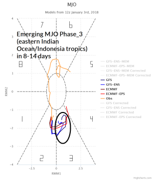
Fig. 2: The Madden Julian oscillation 2-week forecast indicates an intensifying phase 3 in 8-14 days.
The MJO will cause an upper trough to form in the Aleutian Islands/Gulf of Alaska by the 11-15 day period (Fig. 3). East of that trough a mild Pacific maritime flow will change the U.S. pattern erasing all extreme cold and favoring widespread anomalous warmth.

Fig. 3: The day 11-15 upper air forecast by the ECM ensemble across the northern hemisphere indicates milder Pacific influence across the U.S. inspired by MJO.


