

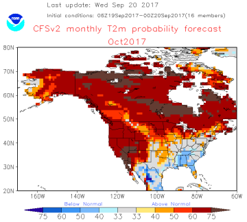
 Central US Drier 8-15 Day Period, Warm into early October: The near term outlook is unchanged, and still rather wet across the Plains and W Midwest. The extended range forecast has trended drier and so harvest progress and crop maturity will be accelerated in the early part of October. The latest CFS Oct temp outlook is attached, and ARC’s climate work also suggests the first half of fall will be marked by normal/above normal temps. Note that NOAA’s official Oct-Dec outlooks will be released Thursday AM.
Lite rain will be scattered across the Central Midwest beginning Thurs, but the bulk of upcoming rainfall occurs Sun-Tues as a noticeable Trough/Ridge upper air pattern is established. Totals of 2-3” are offered to;TX, OK, KS, NE, SD, MN and W IA, and localized totals upwards of 4-5” are possible in KS & NE.
The upper air flow reverses thereafter, and warm and nearly completely dry conditions return in early October.
 Brazil Dry Next 10 Days, Uncertainty Thereafter: The GFS model maintains a slight boost in Brazilian rainfall in the 11-15 day period. But, otherwise dryness will persist in all but far Southern Brazil – and potential rainfall in the 11-15 day won’t be at all soaking in nature. The graphic below reflects that Brazilian rainfall has been below normal since February, soil moisture has been fully depleted, and Brazilian temps so far in Sep have ranged in the 90s and low 100s – 5-15 degrees above normal. The dominating pattern in South America is a strong high pressure Ridge will be anchored aloft eastern Brazil through the end of the month. Additional showers will impact Argentina next week. Otherwise, this Ridge will keep meaningful precip confined to areas south and west of major Brazilian crop producing areas.
The models suggest a more favorable jet stream alignment after Sep 30, but the GFS has been hinting at this seasonal shift for a week to no avail.
The chart to the left reflects that seasonally, October rains normally return – it’s all about the timing.


