

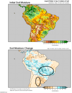
 South American Forecast Unchanged; Brazil Wet, Argentina Dry: There’s no material change to the South American pattern through late Nov. Well above normal rainfall (upwards of 3-6”) will impact much of Central Brazil next week, while precip in Argentina will be isolated to lite/scattered totals today and again next Thurs/Fri. The GFS model hints at high temps in the 90s across Argentina beyond Nov 25. This is likely overdone, but ARC does remind clients that heat is typically exacerbated by the lack of soil moisture. Argentina needs meaningful rain by early December. The projected 7-day change in soil moisture is at left.
The S American jet stream moves northward in the next 48 hours, pushing heavy rainfall into the heart of Brazil’s soy belt. Daily showers of .25-.50” are forecast there Sun-Wed. A second round of widespread heavy showers is likely on Nov 24-26. However, this pattern will not be conducive to rainfall in far S Brazil and Argentina.
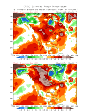 US Forecast Trending Warmer, Still Dry in Plains: The US pattern is warmer in the 8-15 day period, and climate guidance suggests a lasting period of warmer than normal temps in late Nov/early Dec. The CFS model’s 16-23 (top) and 24-30 day temp anomalies are at left, and the return of bitter cold temps to the heart of the US Ag Belt is unlikely through the balance of autumn.
A steady flow of lite/moderate rain will impact the Central and Eastern Midwest over the next 72 hours. Totals in excess of .50” will favor IL, IN, MI and OH. Beyond the weekend, however, near complete dryness takes hold of the entire Central US. This period of dryness is projected to last into the final days of the month, and corn harvest looks to be completed in the next 8-10 days.
Moisture demand is currently isolated to newly planted winter wheat, but a close eye will be on Plains soil moisture through winter. A slight expansion in abnormal dryness is probable.


