

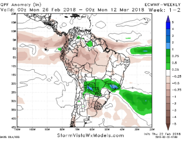
 Argentina Still Dry; Harvest Delays Apparent in Brazil: The EU & GFS models are in general agreement with respect to improved rainfall in far Western Argentina in the next 10 days, but maintain near complete dryness across Argentina’s primary crop belt through mid-March. It’s unlikely that the pattern there changes prior to the end of the growing season. Too much rain is also falling in parts of Central Brazil, where in Parana soybean harvest stands at just 9% complete, vs. 31% on this week a year ago. Ongoing rainfall in Brazil is also unlikely to change in the near term. Two-week precip anomalies are at left.
ARC also mentions that, amid a severe lack of soil moisture, temps in Argentina will stay a bit above normal. High readings into March 5th will range mostly in the upper 80s, and so yet more declines in subsoil moisture lie in the offing.
Argentine yields are fully expected to be 20-30% below trend. Next up is the pace of Brazilian safrinha corn planting, which is already behind last year, and windows of dryness are desired in Central & Northern Brazil.
 US Pattern Remains Stagnant; Flood Concern Expanding in South: A narrow band of heavy rainfall will impact the Delta/Southeast and Southern Midwest in the next 24 hours. Yet more rain works across the Eastern US later next week, and possibly again in the 12-15 day period. 7-day totals are below, and totals upwards of 7-8” will impact pockets of AR, TN and far W KY, making grain transportation difficult in the weeks ahead. Unfortunately, a westward expansion in rainfall is not expected into the middle part of March.
Drought will be eased across the heart of the Corn Belt over the next 10 days, and 60-day rainfall now rests at 100-300% of normal in NE, IA, IL & IN. 60-day precip is still 0-25% of normal across a majority of the HRW Belt. Drought will deepen further there in the weeks ahead, and recall updated monthly winter wheat crop ratings will be released late next week.
A change in this pattern is not foreseen through March 15.


