** AgResource Pre Opening Sunday Market Calls: Soybeans 1 cent higher to 2 cents lower, corn steady to 1 cent higher with wheat called 1-2 cents higher.
** Sunday Weather & Market Comment Discussion: Opening week calls are mixed as the CBOT starts to acutely focus in on Thursday’s USDA March 1st Stocks and Seedings Intention report. The report is expected to be bearish soybeans with US March 1st soybean stocks and US Seeding Intentions to be record large. The grain data is being called supportive with US corn seeding to decline from last year with US wheat stocks well below last year. ARC notes that the CBOT is closed Friday for the Easter Holiday, and that a 3-day weekend, end of the month and quarter all loom. This calendar fact along with US trade tensions will likely hike CBOT market volatility this week.
Friday’s CoT report showed that the managed money is; short 56,000 contracts of Chi wheat (up 20,000), long 213,000 corn (down 20,000), long 196,000 soybeans (down 13,000), short 25,000 soyoil (up 4,000), and long 99,000 contracts of meal (down 12,000).
** Central US Weather Pattern Discussion: The North American EU model 10-day rainfall forecast is attached. Note that the forecast features more above normal rainfall for the Delta and the southern half of the Midwest. The cold and soaking rain will further delay Southern US corn seeding and limited rains are slated to fall on the drought areas of the Plains, adding further acute stress on HRW wheat.
** EU Model 10 Day Precip Forecast: Plains Drought to Deepen While Delta/S Midwest Spring Seeding Slows:

** March 1-31 Percent of Normal Precip; the Plains Drought Deepens While the Midwest is Cold
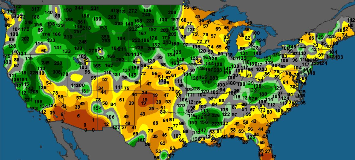
Rain/snow occurred across the C and E Midwest on the weekend (.2-2.00″) and more of the same is expected in the week ahead. A new storm system will take aim on the Midwest from late Tuesday into Thursday with .4-2.00” of moisture expected. Some of the precip will fall as snow. A second storm system will take aim across the E Midwest in the opening days of April.
Below to much below normal temps persist thru the 2-week forecast with some of the coldest temps in the 1st week of April. Any spring seeding will be slow to start due to the ongoing cold/wet weather conditions.
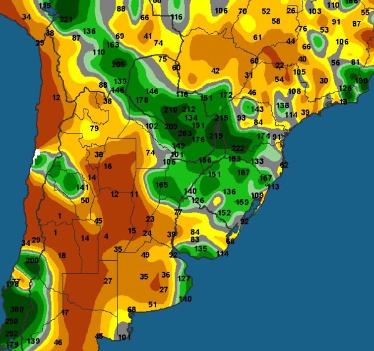
** South American Weather Pattern Discussion: The US and EU weather models are in good agreement that limited rains will fall across Argentina in the next 10 days, deepening the drought and producing nearly complete losses for the 2nd corn/soy crops. The attached map and drawn drought area reflect just a few spits of moisture which along with warm temperatures will elevate worry for summer row crop yields and the new wheat crop soon to be seeded. High temps look to range from the 80’s to lower 90’s.
The Brazilian forecast features ongoing above normal rainfall for the winter corn crop. There is no evidence of a withdrawal of the rainy season into mid-April. Safrinha corn is flourishing.
** EU Model 10 Day South American Rainfall Forecast; Drought to Deepen Across Argentina:

** March 1-31 Rainfall Percent of Normal: