

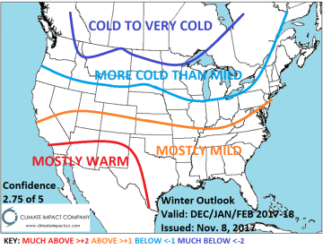
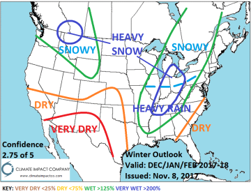
Winter 2017-18: A composite of the 3 meteorological winter months indicates the winter season is colder than normal across the northern U.S. while the southern states are warmer than normal. The storm tracks are potent across the East-Central U.S. and northern Rockies. The northern states gain a substantial snow cover this season causing the persistent northern chill. Very warm conditions are likely in the Southwest.

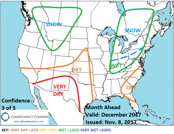
December 2017: The first month of meteorological winter is adjusted a little colder across the northern U.S. caused mainly by established snow cover. Occasionally, some of the cold surges southeastward causing a slightly less war forecast in the East. In the absence of cold outbreaks from Canada mild Pacific flow is dominant. Warm and dry climate is projected for Texas and vicinity. Storm tracks are most evident in the Interior Northwest (all snow) and Ohio Valley to Quebec. The snow cover in Quebec piles during early winter and could bias the Northeast U.S. colder than indicated.


January 2018: The northern U.S. is adjusted colder as mid-winter (deep) snow cover is difficult to dislodge despite occasional MJO-inspired warmth trying to push north from the U.S. The southern states remain in the warm category for mid-winter. The East-Central U.S. storm track is intense. Heavy snows are likely for the northern Ohio Valley and into Ontario and Quebec. The Northwest U.S. is also stormy with heavy snows over the Cascades and northern Rockies.
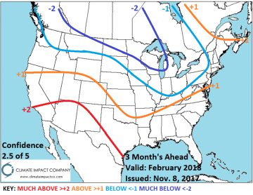
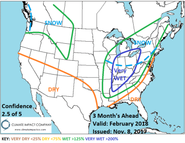
February 2018: Meteorological winter ends on a very cold note in south-central Canada to the Upper Midwest U.S. enhanced by presence of deep snow cover. The cold frequently surges into the Ohio Valley where snow cover is also above normal. A snowy pattern is forecast for the Great Lakes region to the Interior Northeast U.S. Interior Northwest snows continue to pile supporting late season cold. The La Nina inspired warm pattern continues to affect most of the southern states. A dry climate is also persistent across the Southwest U.S. and coastal Southeast to Florida.


