

The ENSO phase trend during quarter 4 of 2017 (so far) is a choppy pattern toward weak La Nina. La Nina remains forecast for northern hemisphere winter but onset holds off until later December or early January. This development time is late for a typical La Nina episode. There remains the possibility that a very borderline La Nina not quite completely reaching La Nina thresholds continues through the winter season.
The issue is the anomalous warmth of the North Pacific to the north of the East Pacific tropics. The subtropical latitudes are unusually warm given presence of a developing La Nina. In fact, globally the oceans are near record warmth for the 5th consecutive year. The warm pattern is preventing cold inflow into the equatorial region from the California Current off the West Coast of the U.S. Normally, this cool current would be enhancing La Nina with a pattern referred to as the cool phase of the Pacific decadal oscillation.
Given the general warmth of the North Pacific and North Atlantic the influence will be to weaken traditional La Nina climate for northern hemisphere winter. Transient features such as Madden Julian oscillation and continental snow cover will be the primary catalyst for the winter weather patterns. The southern hemisphere La Nina is stronger therefore influence on Australia (wet eastern areas) and South America (wet Brazil) are more likely.


Fig. 1-2: Current global SSTA analysis with annotated key regimes governing the climate patterns (left). A typical La Nina SSTA signature is much cooler than current observations and forecasts (right).
Diagnostic Discussion: The ENSO regime and forecast is complicated by the near record warmth of the global oceans (despite no El Nino). Unique to the Pacific Ocean is the widespread anomalous warmth of the subtropics which is interfering with the evolution of La Nina.
Currently, equatorial sea surface temperature anomalies (SSTA) in the equatorial East Pacific are just below La Nina thresholds (Fig. 1). The SSTA trend has been inconsistent trending toward La Nina onset in early-to-middle October and more recently backing off cold ENSO. A transient and robust Madden Julian oscillation (MJO) signal the past 4 weeks has caused the inconsistent La Nina trend disrupting the trade winds in the tropical East Pacific necessary to up-well plentiful subsurface cool water.
Normally, La Nina will attract cool inflow from the Humboldt Current off the South America Coast and the California Current off the U.S. West Coast (Fig. 2). While the Humboldt Current has pushing cool surface water into the equatorial East Pacific causing the weak La Nina signal the warmth in the subtropical East Pacific is blocking the cool inflow from the California Current. Therefore La Nina 2017-18 is likely weak and short-lived.
The Pacific decadal oscillation (PDO) has lost its potent warm phase signature present much of the last 3-4 years. Currently, the PDO is near neutral. Normally, the cool phase of PDO runs parallel with La Nina. The lack of a -PDO pattern also implies La Nina ahead is weak.
In the North Atlantic anomalous warm SSTA off the U.S. Northeast Coast and in the eastern basin has caused robust warm phase of both the Atlantic multi-decadal oscillation and tropical North Atlantic index. The +AMO and +TNA pattern played a significant role causing high intensity tropical cyclones to form this past season.
Finally, despite the Bureau of Meteorology/Australia stating the Indian Ocean Dipole is in neutral phase a weak positive phase appears due to the cool waters northwest of Australia and the warmth in western tropics of the Indian Ocean. The +IOD influence was dryness across Australia this past winter and early spring but this feature seems to be weakening and Australia has gained some beneficial rainfall in recent weeks.
Forecast discussion: Using the NMME forecast model the global SSTA outlook for DEC/JAN/FEB 2017-18 indicates moderate La Nina, continuation of the +AMO pattern in the North Atlantic, unusual presence of widespread subtropical North Pacific warmth, areas of subtropical warmth in the southern hemisphere and open water of the Norwegian Sea due to warmer than normal water (Fig. 3).
Implications include a weak La Nina climate as the global ocean warming somewhat inhibits full throttle cold ENSO climate effects. The +AMO pattern biases the eastern U.S. and Europe mild during this winter season. The subtropical warmth across the North Pacific causes a warm pattern across the southern U.S. and the PDO is likely neutral. Anomalous warmth in the Norwegian Sea raises the risk of high latitude high pressure blocking during the winter season causing some middle latitude regions anomalous snow and cold (most likely central North America). The regional (versus widespread) subtropical warmth across the southern oceans suggests a more transitional rather than locked in summertime upper air pattern.


Fig. 3-4: The global SSTA forecast for DEC/JAN/FEB 2017-18 using the NMME forecast model with key regions annotated (left). The global SSTA forecast for APR/MAY/JUN 2018 using the NMME forecast model with key regions annotated (right).
The outlook for APR/MAY/JUN 2018 using the NMMA model indicates La Nina fades while the North Pacific and North Atlantic are unusually warm approaching the northern hemisphere summer 2018 season.
Finally, the ENSO forecast using the Bureau of Meteorology/Australia forecast model indicates a short duration and weak La Nina ahead (Fig. 5). ENSO flips to neutral phase by late quarter 1 of 2018.
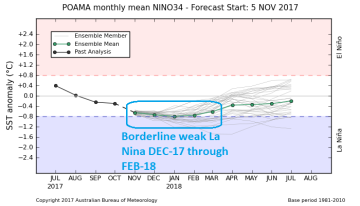
Fig. 5: Bureau of Meteorology/Australia ENSO phase forecast to next July.
Implications: The La Nina 2017-18 is likely weak and short-lived and possibly weaker than indicated by the NMME model. Given the warmth of the northern hemisphere oceans the La Nina influence on winter climate is likely weak. However, La Nina has a more pronounced character in the southern hemisphere. Therefore a more reliable La Nina climate is likely in Australia (wet eastern portions) and South America (wet in Brazil).


