

Download The Climate Impact Company Month 1-3 Ahead Forecast
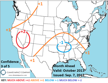

October 2017: Most striking with the October outlook is the potential excessive wet regime in the northern Mid-Atlantic suggesting a possible late season tropical event which is certainly possible given the warm North Atlantic. The warmth of both the subtropical Pacific and North Atlantic basin almost certainly leaves mid-autumn warmer than normal nationally. Strongest warm anomalies are in the Southwest U.S. and dryness persists in California and the southern Plains to Texas and Louisiana. Wet weather is forecast for the coastal Northwest. The forecast trend is warmer with increased emphasis on Northeast rainfall. Â


November 2017: Late autumn is warmer than normal across most of the U.S. primarily due to the influence of warm SSTA on the upper flow pattern. The warmest anomalies are across the Interior West while the East Coast is temperate. Wet weather is likely in the Great Lakes/Ohio Valley region which will include some snow cover. The Northwest trends wetter (including northern California).


Preliminary December 2017: Meteorological winter begins with a warm influence in the East by a mean ridge position correlated to warm SSTA in the western North Atlantic. The flat PDO regime implies a zonal flow is likely in the West causing a wet pattern with (heavy) mountain snow particularly northern California. Arctic air gathers in Alaska and occasionally seeps southward into the Interior West and northwest Plains.


