

Please download the full CIC June, July and August 2018 climate outlooks.
Executive summary: The Climate Impact Company Month 1-3 Ahead Forecast for the U.S. is updated. Forecast highlights include more thermal volatility as the East cools to near normal in June after a very warm May which followed an unusually cool April. Motivated by drought the Southwest U.S. is hot in June with the anomalous heat shifting into the Northwest in July. Summer 2018 is temperate in the Southeast where precipitation forecasts could be wetter than indicated. The Great Plains are warmer and drier than normal through July lending support to dry concerns followed by a wetter/cooler pattern change in August. Finally, mid-to-late summer looks warm and humid for the Northeast Corridor.
Climate discussion: Given neutral ENSO close attention to soil moisture trends and regional SSTA regimes is warranted as lead predictors of the summer climate ahead. The focus is on the SSTA regime (Fig. 1). Very warm SSTA off the Northeast Coast guarantee a semi-persistent warm, humid and wet regime for the Northeast Corridor. Warm SSTA in the southeast North Pacific are causing the Southwest U.S. drought and attendant widespread anomalous heat. In-between these 2 summer regimes the mean trough position is in the Corn Belt.
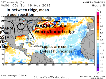
Fig. 1: North Atlantic SSTA analysis and U.S. climate influence.
June 2018: Thermal volatility from month-to-month continues. After record cool temperatures in April just-the-opposite occurred in May. In the East, the late spring anomalous warmth in the East gives way to more wet weather suppressing heat risk. Just-the-opposite, hot and dry weather dominate the Southwest quadrant of the U.S. inspired by drought. Frequently, the anomalous heat in the Southwest shifts into the Great Plains.
The East-Central U.S. is marginally warm and dry. The wet weather set-up for June is definitely in the East and the Southeast could be wetter than the dry forecast presented by the constructed analog. Texas drought expands to Louisiana. In the Northwest a borderline cool/wet regime is indicated which could be warmer/drier than indicated by the constructed analog.


Fig. 2-3: The Climate Impact Company month ahead forecast for June 2018.
July 2018: The mid-summer outlook for the U.S. indicates 3 regimes. The hot weather across the Southwest eases slightly due to Monsoon thunderstorms. The anomalous heat shifts north into the Northwest U.S. where the forecast could (also) be drier than indicated by the constructed analog. The dryness during mid-summer is focused on the North-Central/Midwest U.S. and coupled with anomalous warmth sneaky dry soil conditions develop.
The Southeast U.S. is temperate. Wet weather, possibly related to a tropical event affects the northwest Gulf States. Dryness is forecast across Georgia with low confidence (could be wetter). The Northeast States are showery/thundery with warmer and more humid than normal climate likely.


Fig. 4-5: The Climate Impact Company 2 months ahead forecast for July 2018.
August 2018: Yet another pattern change in August. Support by regional warm SSTA certainly favor a warm ridge in the West and Northeast U.S. This set-up implies the mean trough position is in the Midwest States. The mean trough forecast is in full force in August bringing needed rain and cooler temperatures to the Midwest (after a hit July). The upper trough invites tropical rainfall in the northern Gulf States possibly related to a tropical cyclone.
The Northeast is likely to remain thundery, warm and very humid to close meteorological summer. Most of the East is wet during August. While the northern Gulf States are wet, Texas is dry and hot. In the Far West the warm SSTA of the southeast Pacific inspires continuation of the hot/dry ridge pattern.


Fig. 6-7: The Climate Impact Company preliminary 3 months ahead forecast for August 2018.


