

Day 1-5 Outlook (Jan. 7-11, 2018): Cold retreat, turning much warmer.
- Extraordinary cold across the Northeast/East this morning retreats tomorrow.
- Freezing rain/icing on front edge of warm-up Ohio Valley today.
- Heavy rain Mid-South SUN/MON; wet in Florida TUE.
- Big warm-up Central U.S.
- But! Midweek cold front and 4-10 in. snowstorm to follow.
- Heavy rain/mountain snow rolls into California tomorrow.


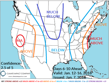
Day 6 to 10 Outlook (Jan. 12-16, 2018): Cold returns, less intense.
- Cold air mass into Central U.S. follows a potent (mostly rain) storm in the East into early next weekend.
- Cold is less extreme; limited arctic air.
- Snowy Upper Midwest/Great Lakes region.
- West Coast turns stormy; excessive precipitation into northwest U.S. (heavy snows).

Day 11-15 Outlook (Jan. 17-21, 2018): Re-emerging warmth; West could be colder.
- Warmth might be less dramatic than indicated.
- Western chill could be stronger as veil of new snowfall emerges.
- East is dry and quite mild.


Week 3 & 4 Outlook (Jan. 21-27/Jan. 28-Feb. 3, 2018): Warmth East.
- Quite mild East-Central/East Jan. 21-27.
- Into early February eastern warmth is decelerating while West to Central chill develops.
- Not seeing extremes late JAN/early FEB.


