

Executive summary: The Climate Impact Company Month 1-3 Ahead Forecast for the U.S. is updated. The outlooks are based on past similar climate when ENSO was transitioning toward El Nino, Pacific decadal oscillation was weak negative and the Atlantic multi-decadal oscillation was neutral. A significant contributor to the forecast is the U.S. soil moisture regime and trend. The July outlook is hot everywhere except the Mid-South while the Corn Belt dries out. The outlook is similar to the previous forecast. In August the East turns wetter and cooler while Texas and California are hot. Midwest rains likely regenerate. The preliminary outlook for September favors cool and wet conditions in the Midwest and still warm-to-hot elsewhere.
Climate discussion: The outlook is based on an ENSO pattern looking more determined to transition into El Nino before meteorological summer ends, a weak cool phase of the Pacific decadal oscillation (-PDO) which could shift back to neutral as weak El Nino arrives and a neutral Atlantic multi-decadal oscillation (AMO).
The subsurface equatorial central and east Pacific Ocean is very warm and warming strongly implying that El Nino is not far away. In the north/northeast Pacific SSTA are warming north of Hawaii while cooler SSTA are present in the northeast North Pacific indicating the weak trend toward weak _PDO continues. If El Nino develops later this summer as expected the –PDO regime should shift back toward the positive phase.
In the North Atlantic a tale of much different regimes as the far northern North Atlantic and areas east of the Mid-Atlantic U.S. are very warm while a broadening cool pool of SSTA rests south of Greenland. The central and east tropical North Atlantic are also cooler than normal. The combination of these dramatically different SSTA regimes averages to neutral AMO.
The soil moisture regime is also dramatic featuring strong drought across the Southwest U.S. to Kansas and Texas while East U.S. soils trend wetter. Usually soil moisture observations/trends in early June strongly foreshadow the summertime thermal regime ahead whereas drought areas are hotter than normal and wet soil regions observe suppressed heat.
A combination of the SSTA regimes and soil moisture implications are combined to generate the constructed analog forecast for July, August and September.

Fig. 1: Soil moisture entering the month of June whereas dry soils foreshadow anomalous heat ahead and wet soils tend to suppress heat.
July 2018: The July forecast remains consistent with the heat core of a nationally very warm pattern forecast to shift to the Northwest U.S. and extend into the dry pattern of the Central Great Plains. An anticipated warming of the already warm SSTA east of the Northeast Corridor supports anomalous warmth and humidity in the Northeast States while a chilly pattern lifts northward through Quebec. Southern/central Great Plains drought extends into the Corn Belt. A tropical system brings wet weather to the northwest Gulf region. The Southwest wet Monsoon arrives to ease anomalous heat. Parts of the Southeast are dry and normally hot while wet patches affect the East U.S.

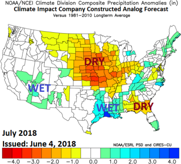
Fig. 2-3: The Climate Impact Company month ahead forecast for July 2018.
August 2018: The late (meteorological) summer outlook remains wet in the northwest Gulf of Mexico possibly due to a tropical event and a thundery pattern persists in the Mid-Atlantic region. Dryness in the Great Plains affects mainly southwest portions while a thunderstorm regime evolves in the Corn Belt. The arc of Monsoon thunderstorm activity is Arizona to Montana/North Dakota. The hot anomalies remain consistent with the previous forecast settled on the West Coast and Texas. The eastern states trend a little cooler.
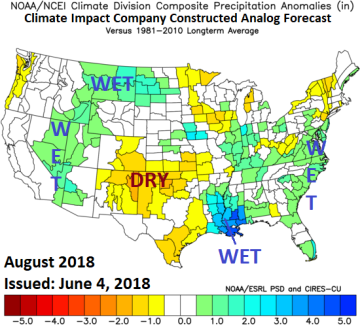
Fig. 4-5: The Climate Impact Company 2 months ahead forecast for August 2018.
Preliminary September 2018: The hot zone remains the western states while the South U.S. also finishes calendar summer warmer than normal. The southern states could be cooler than indicated due to the fairly widespread anomalous wet climate. The wetter southern U.S. climate is due to onset of El Nino. Typical of El Nino dryness becomes dominant in the northern states. The eastern Corn Belt is thundery and cooler than normal.

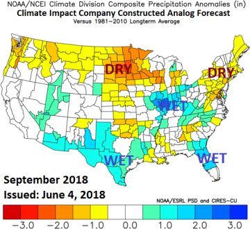
Fig. 6-7: The Climate Impact Company preliminary 3 months ahead forecast for September 2018.


