

Download the Week 2-4 Forecast for South America


Pictured: Last week’s temperature anomaly and precipitation amount observations for central and northern South America.
Last week heavy rains returned to Uruguay into northeast Argentina, a common feature during the past season. Meanwhile to the north Brazil is very dry with anomalous heat Interior Southeast Brazil. This persistent pattern has been caused in-part due to a strong subtropical ridge southeast of Brazil. The warm ridge is reflected in the sea surface temperature anomaly pattern which is warmer than normal southeast of Brazil. Occasionally, strong cold fronts surge north into southern Brazil and as they do they invite tropical moisture igniting the frontal trough from Bolivia to northern Argentina. The persistent upper trough has been located southeast of South America the past 90 days as reflected by the cool SSTA to the west/southwest of South America.

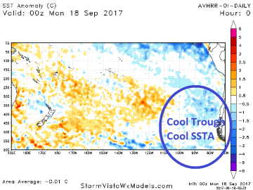

Pictured: Causing the Argentina rains is the meeting place between weather caused by an upper trough southwest of South America and a ridge pattern southeast of Brazil. The cool trough and warm ridge are reflected in the SSTA pattern on either side of South America.


