

 South American Weather Generally Favorable; Argentina Needs Watching: The outlook through the latter part of November in South America is non-threatening, but somewhat quietly pockets of Argentina have been much drier than normal over the last 30 days. This isn’t yet an issue by itself, but does raise warning flags as La Nina develops, and as a warm/dry pattern is forecast across much of Argentina through the next 10 days. A needed surge in Brazilian soil moisture is still indicated.
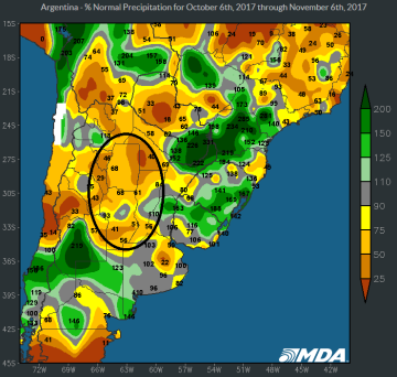
A rich monsoonal flow will persist across nearly the whole of Brazil into Sat/Sun. Totals in excess of 3” will favor Mato Grosso, Goias and fringe producing areas in far Northern Brazil. Needed drier weather will be established next week across Paraguay, S Brazil and Argentina, which again offers no immediate threat. But soil moisture has been in retreat across Cordoba and Northern Argentina in recent week, and the area highlighted at left accounts for some 45-50% of Argentine corn/soy production. It’s important that regular rainfall resumes there by late month.
 US Forecast Much Drier Next Two Weeks: The US forecast over the weekend trended steadily drier, and a noticeable lack of rain is scheduled over the next two weeks. NOAA’s QPF this evening keeps meaningful precip through the coming weekend isolated to the Delta/Southeast, while the major forecast models (and NOAA) agree that only lite rain will affect the Eastern Midwest next week.
A more zonally flowing jet stream is forecast over the next 10 days. Extreme cold will be limited to the far Northern US, and just one frontal system is indicated mid/late next week. Upcoming weather will be far more conducive to corn harvest.
In the near term regionally heavy showers will impact LA, AR, MS, GA and TN. Near complete dryness is forecast elsewhere. Scattered showers are hinted at next Tues-Thurs across MO, IL, IN, OH and KY, but heavy rain is not indicated.


