

** AgResource Pre Opening Sunday Market Calls: Soybeans 3-5 cents lower, corn 1-2 cents lower, with wheat called 1-2 cents lower.
** Sunday Weather & Market Comment Discussion: Opening week calls are slightly lower on the growing net long CBOT fund position and the meaningful rain that fell in some of the key soy growing areas of Argentina this weekend. And the parched areas of the Central US Plains will also receive some needed moisture.
The USDA March Stocks and Seeding Report looms in 10 trading sessions along with the end of the month and quarter. And Trump trade uncertainty prevails with rumors of new tariffs to be announced against China ($30-60 Bil) this week while steel/aluminum tariffs become active. The EU is rumored to be targeting US corn in a retaliatory response, but last year the US exported less than 30 Mil Bu of corn to the EU – just 1.3% of the US total.
Friday’s CoT report showed that the managed money is; short 36,000 contracts of Chi wheat (up 3,000), long 233,000 corn (up 70,000), long 208,000 soybeans (up 24,000), short 21,000 soyoil (up 12,000), and long 111,000 contracts of meal (down 4,000). Funds were longer than expected in soymeal, corn, and soybeans. Funds are holding a record net long soy complex position of 274,000 contracts.
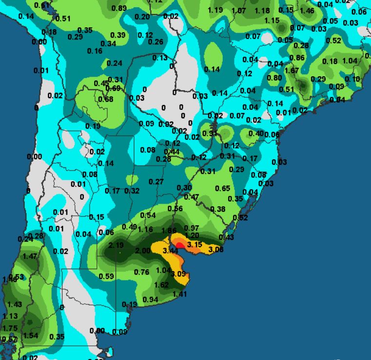
** Mar 16-18 Rainfall; Better than Expected Across Key Argy Soybean Area:
** March 1-31st Percent of Normal Rainfall; Drought Deepens

** US Plains Weather Pattern Discussion: A storm system is expected to produce some lite to moderate moisture for the Plains early this week, the first good chance of precipitation in months. Some nice rains have already fallen across the Texas Panhandle and SW Oklahoma. The rains will spread north and east into Tuesday. Rainfall totals are estimated in a range of’ .2-1.00” with another chance of moisture next week, and again in the opening days of April.
** 10 Day EU Model Precip Forecast for North America;

** 15 Day North American Temperature Anomaly:

** South American Weather Pattern Discussion: The US and EU weather models are in fair agreement with the EU model being wetter for Argentina and N Brazil over the next 10 days. Both models offer another chance of rain on Friday and the weekend, but rain totals/locations are still being sorted out. Based on the weekend rains and the EU correctness in getting it right, our forecast is based more on the EU model forecast.
A few additional lite showers are expected to fall across N Argentina in the next 12 hours before mostly dry weather returns for Monday thru Thursday. Shower chances will increase on Friday/Saturday with totals of .25-1.50” and a few locally heavier amounts. There additional rain in the 11-15 day forecast. Note that near to above normal rains will continue across much of Brazil favoring their winter corn crop.
** 10 Day EU Model South American Rainfall Forecast:


