

February 2018: Emerging snowy pattern Interior Northwest and Ohio Valley. Warmth across the South with cold risk Northwest. Cold could shift farther east given snowy Midwest forecast.


Fig. 1-2: NOAA probabilistic temperature and precipitation forecasts for February 2018.
FEB/MAR/APR 2018: A cold/stormy forecast is indicated across the northern U.S. except slight warm risk in New England. The southern tier is projected warmer and drier than normal. The forecast is characteristic of mature La Nina climate.


Fig. 3-4: NOAA probabilistic temperature and precipitation forecasts for FEB/MAR/APR 2018.
JUN/JUL/AUG 2018: NOAA maintains a warm risk in the West, South and East for summer. The Northwest is dry and the Northeast is wet. Climate Impact agrees with the western warmth and dryness but prefers a more widespread wet regime in the East and Gulf States with a trailing dry zone in the Midwest.


Fig. 5-6: NOAA probabilistic temperature and precipitation forecasts for JUN/JUL/AUG 2018.
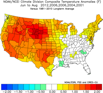
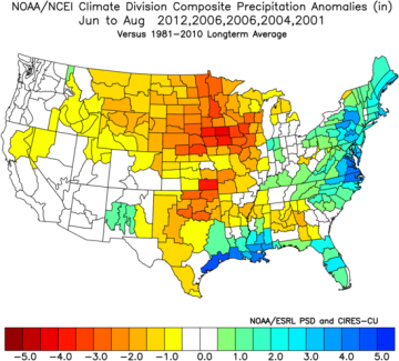
Fig. 7-8: Climate Impact Company ENSO/PDO/AMO analogs and the attendant temperature and precipitation anomalies for summer 2018.
NOAA Seasonal Drought Outlook: The outlook widens southern U.S. drought through April while eroding the northwest Plains drought and northern Missouri Valley dry zone.

Fig. 9: NOAA 90-day drought forecast is indicated.


